

Return to Introduction & Lesson Plans at a Glance
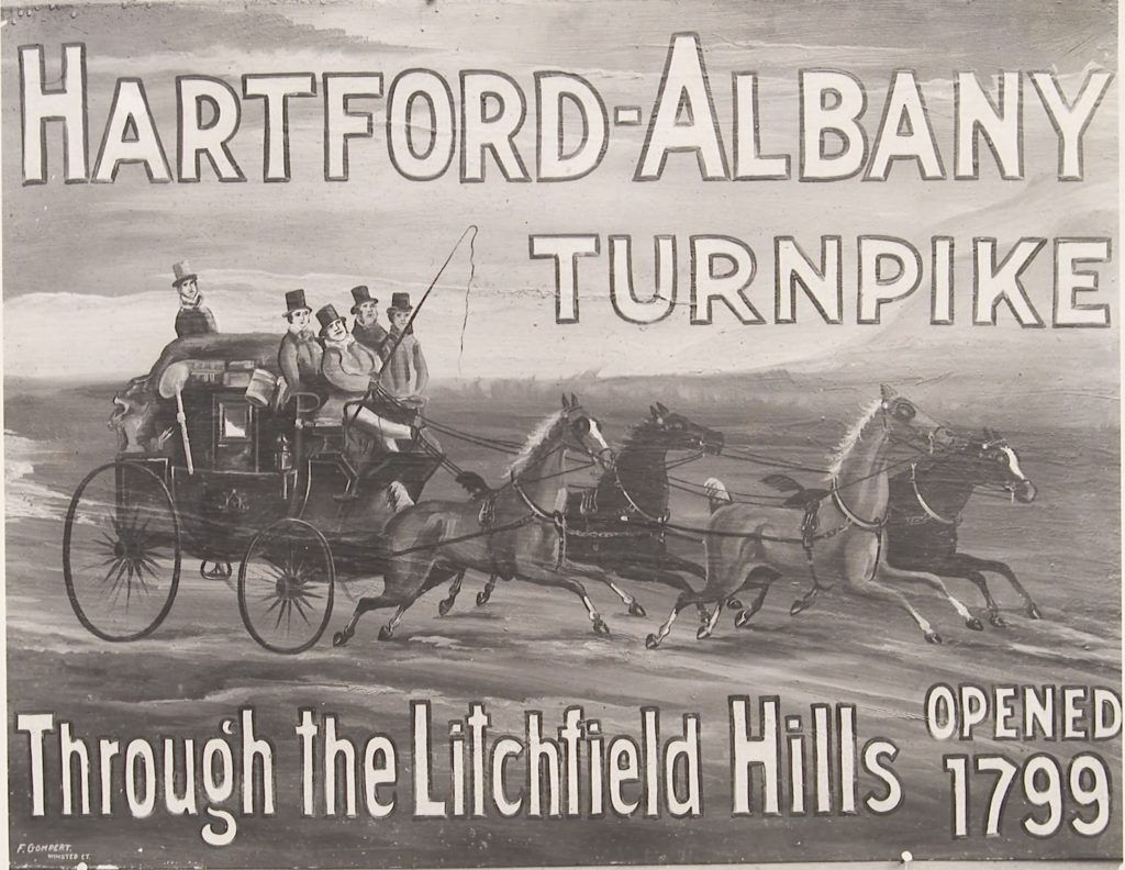 Advertisement for the Hartford Albany Turnpike. State Archives, Connecticut State Library
Introduction
This lesson plan is about how transportation improvements impacted town growth and development.
Objective
Using maps, the story, and song provided, students will be able to cite how location shaped (cause and effect) Litchfield’s economy in the early 19th century.
Grade Level
3 - 6
Introductory Discussion Questions
After students read Where I Live: Connecticut chapter 1 and chapter 7, pages 57 - 59, begin with an in-class discussion about how early towns and villages were connected by roads and turnpikes, and why inland towns that were not on the navigable waterways benefited by roads and turnpikes.
Here are some questions to help guide the discussion.
Q. Where would be a good place to settle a town?
A. Most towns grow up around some type of major transportation such as sailing ships, steamboats, stagecoaches, railroads, or interstate highways.
Q. How did Connecticut’s first settlers travel inland across Connecticut? How would you go to another town to visit your family, or send packages to friends or customers?
A. The first settlers of inland towns like Litchfield traveled by horseback over established roads and “trodden paths” made by Native Americans. These paths skirted swamps, the steepest hills, large boulders, trees, and other obstacles, taking advantage of gaps through hills, and fording rivers and streams at low points.
Q. How could you improve these paths so you could get your horse and wagon through?
A. The dirt roads and paths were widened by chopping down the trees of the dense forest so that teams of horses and wagons could travel the road. Settlers also had to be able to drive livestock (cattle, pigs, and horses) to their new settlements. English settlers founded 100 separate towns during the colonial period and built a crude but passable network of dirt roads to connect these towns.
Q. What is a turnpike?
A. Beginning in the 1780s, the state government authorized private companies, called turnpike corporations, to build roads and collect tolls from travelers. Connecticut chartered 120 turnpike companies and constructed 1,600 miles of turnpike toll roads across the state. Ask students if they have ever taken a trip where you had to pay a toll to use a highway in your car—like the Mass Pike. Turnpikes had toll keepers who collected tolls that went to the private company. Today they are operated by the state. Connecticut is considering tolls again.
Q. What is a stagecoach?
A. A large, covered horse-drawn carriage used to carry passengers, packages, and mail along a regular route between two places.
Q. What is a stagecoach route?
A. Ask students if they have ever taken a bus, train, or plane where they had to buy a ticket, go to the station and be there at a scheduled time to get their ride. The stagecoach route included those things: paid passage, specific departure places, and a schedule. Stagecoach routes operated on turnpikes. In 1783, it took six days to travel from New York to Boston. By 1827, it was down to 36 hours. Today it would take about 3 ½ hours.
Q. What kind of buildings would you find in towns along a stagecoach route?
A. Taverns, inns, post offices, general stores, stables, and barns.
Q. How would it help your town grow if it was on a stagecoach route?
A. More people would pass through it and spend money in the local shops and taverns; shopkeepers, tavern owners and other small businesses would open for business; farmers and small factory owners would come to town to ship produce and goods to other places.
Q. What do think might happen when the railroad was invented if it didn’t go near the towns on the stagecoach route?
Lesson Activity & Procedures
Before or after students read "Transportation Hub: Litchfield," have them listen to "Pay As You Go" by Sally Rogers (link at the top of this post and also at the bottom of the student essay linked below). At the bottom of the student essay there is a primary source image of toll road tickets that relate to the song.
Distribute or link to the student reading materials
Then,
1. Split up your students into small groups. Print out or otherwise share the three maps with each group:
a. Turnpike map (about 1860)
b. Railroad map (1893)
c. Highway map (2018)
2. Have students spend time examining the maps closely and annotating them. First, students should locate the five major cities on each map: Hartford, New Haven, Bridgeport, Waterbury, and Stamford. Second, they should locate Litchfield on each map. Have them write down any general observations about the differences and similarities between the maps. (They might note, for example, that the major railroad lines and later the major highways are located in similar places, that all of the major cities have turnpikes, railroads, and highways going through them, that railroads and highways generally go from southwest to northeast and fewer go from southeast to northwest.) Using their knowledge of geography, have them make some guesses as to why that is.
3. Have the students make particular observations about Litchfield from these maps.
4. OPTIONAL: Choose one other town or city for the students to study in comparison. One example might be Plainville and you can use the My Town: Plainville available on WhereILiveCT.org. This town is not far from Litchfield but has a very different history because of its geography and the impact of yet another form of transportation, the short-lived Farmington Canal. Or, to keep it simpler, choose Bridgeport (story also available on WhereILiveCT.org) which did not become a city until the railroad came through.
5. Have students use their observations to complete this exit slip:
Litchfield was (choose one: quiet or busy) during the era of the turnpike. When railroads replaced the turnpike as the fastest way to travel and ship products, Litchfield (choose one: got busier or got quieter). When the interstate highway was built in the mid-20thcentury, it was (choose one: close or far away) from Litchfield. This resulted in Litchfield becoming ____________.
____________ (the other town) was (choose one: quiet or busy) during the era of the turnpike. When railroads replaced the turnpike as the fastest way to travel and ship products, (fill in the town) got (choose one: busier or less busy). When the interstate highway was built in the mid-20thcentury, it was (choose one: close to or far away from) (fill in town). This resulted in (fill in the town) becoming ____________.
Transportation (choose one: is or is not) as important to our town’s economy today. Why/Why not?
6. ANOTHER OPTION: Read "Canal Crazy in Connecticut" and compare and contrast turnpikes and stagecoaches with canals and canal boats. Canal Crazy includes a map showing the route of the Farmington Canal. Another map to explore!
Additional Resources
Additional Resources
From Connecticut Explored
Litchfield’s Fortune’s Hitched to the Stagecoach, Connecticut Explored
https://www.ctexplored.org/litchfields-fortunes-hitched-to-the-stagecoach/
The Influence of the Litchfield Law School, Connecticut Explored
https://www.ctexplored.org/the-influence-of-the-litchfield-law-school/
Connecticut’s Ruling Aristocracy 1639-1818
https://www.ctexplored.org/the-standing-order-connecticuts-ruling-aristocracy-1639-1818/
From Connecticuthistory.org
https://connecticuthistory.org/towns-page/litchfield/
https://connecticuthistory.org/stagecoach-travel-sustained-commerce-and-communication-in-1800s/
https://connecticuthistory.org/overland-travel-in-connecticut-from-footpaths-to-interstates/
https://connecticuthistory.org/levi-pease-stage-route-and-transportation-innovator/
Litchfield Historical Society at https://www.litchfieldhistoricalsociety.org/
The Litchfield Historic District is listed on the National Register of Historic Places, National Park Service, U.S. Dept of the Interior.
Nomination, National Register of Historic Places, David F. Ransom, 1978.
https://npgallery.nps.gov/NRHP/GetAsset/NRHP/78003456_text
The Litchfield Historic District was designated a National Historic Landmark by the National Park Service, U.S. Dept of the Interior, in 1968.
https://npgallery.nps.gov/AssetDetail/NRIS/68000050
Word Wall
Stagecoach, turnpike, toll
State Standards Alignment
ECONOMICS
Economic Decision-Making
ECO 3.1 Compare the benefits and costs of individual choices.
Compelling Question:
· How do we trade for goods and services?
Supporting Questions:
· Why do we live where we live?
· How do we get the things we need to live (food, clothing, goods, etc.)?
GEOGRAPHY
Geographical Representations: Spatial Views of the World
GEO 3.1 Construct maps and other graphic representations of both familiar and unfamiliar places.
GEO 3.2 Use maps, satellite images, photographs, and other representations to explain relationships between the locations of places and regions and their environmental characteristics.
GEO 3.3 Use maps of different scales to describe the locations of cultural and environmental characteristics.
Compelling question:
· Why do we live where we live?
Supporting questions:
· Why is your town/city/state shaped the way it is?
· What economic or geographic features have caused people to move in (or move out) of your town?
Human-Environment Interaction: Places, Regions, and Culture
GEO 3.4Explain how culture influences the way people modify and adapt to their environments.
GEO 3.5Explain how the cultural and environmental characteristics of places change over time.
GEO 3.6 Describe how environmental and cultural characteristics influence population distribution in specific places or regions.
Supporting Questions:
· How is the “identity” of a state or region created?
· What are some of Connecticut’s cultural and historical resources and how did they affect how people lived?
Human Population: Spatial Patterns and Movement
GEO 3.7, 3.8, 3.9 Supporting questions:
· Who controls the use of land and resources?
· How are rivers and resources in Connecticut used to develop communities and economic systems?
· What attracts a person to a town or city today? How is that different from what may have attracted them there in 1800?